Current State of the Stone Bridge at Price’s Ford

Price’s Bridge illustrated in: Bridges: Our Legacy in Stone, by Cottingham 1965

Price’s Mill Bridge, Washington County, Photo 3 of 12 in MHT WA-I-291, by B. Harvey, 1/20/2022
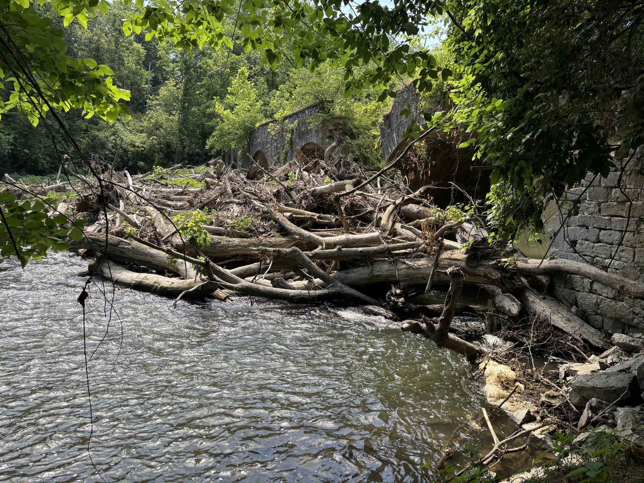
Log jam at Price’s Ford Bridge, June 21, 2024 (ACWA photo)

Signs placed upstream of the Bridge at Price’s Ford by Washington County to alert boaters to the blockage. (photos provided by the County 6/25/2024). The property owner has agreed to temporary access for those recreating to walk around the bridge.
The Bridge at Price’s Ford is one of only two five-arch spans in the County. It is also the second oldest stone bridge built. Located adjacent to Route 58, the Cearfoss Pike over the Conococheague Creek, this beautiful bridge, was built by the Lloyds of Philadelphia in 1822. More commonly called “Price’s Mill Bridge”, William Price’s sawmill was identified to the north and on the west side of the bridge. It is said the bridge was built with stone brought down the Conocoheague by horse-drawn flatboats from the quarry at the Solliday Farm. Confederate soldiers marched across on July 5th 1863, during their retreat from Gettysburg. (Learn more about the bridge history on the WCHT page.)
Unfortunately, the bridge was heavily damaged by Tropical Storm Agnes in 1972. Emergency repairs were made to stabilize the bridge and keep it open for vehicle traffic.
In 1979, a new modern bridge was constructed to serve traffic on Rt 58 and Price’s Mill Bridge was closed. The bridge continues to deteriorate and suffer damage from weathering and neglect. There are differences in opinion by several experts over whether earlier repairs have changed the historical nature of the bridge.
Price's Mill Bridge was first surveyed and added to the Maryland Inventory of Historic Properties in 1975. In 1994, the bridge was determined eligible for the National Register of Historic Places (National Register; Dickey 1994). However, in March 2022, the bridge was deemed “no longer eligible for the National Register” due to its ongoing deterioration and that it “does not reflect its historical associations with commerce and engineering.” (WA-I-291 MHT, 2022)
Currently, logs and debris block all five of the bridge arches putting much stress on the structure. It is also a safety hazard to those recreating on the creek since there is no way to safely float underneath the bridge. If the debris is not cleared, it will continue to build up adding more stress on the structure and surrounding area. The neighboring property owner has suffered land erosion and property damage from the flooding that occurs from the blockage.
In June 2024, volunteers with ACWA placed temporary signage upstream of the bridge to alert boaters to the water hazard. The county later replace the signs with more visible signage. The landowner has graciously agreed to allow boaters temporary access to his property to shuttle their boats on land around the bridge & to regain creek access downstream.
The County is debating on what is the next course of action for the bridge. Should funds be expended to clear the debris? Is demolition the best course of action for safety and land preservation, or should we save this cultural symbol of our region?
There is no public access to this bridge. Please do not access the private roads that once crossed the old bridge or parking on either sides of the bridge as they are private property. The current modern bridge on Route 58 has very narrow shoulders.
The Washington County Historic District Commission (WCHDC) will hear a presentation prior to their regular meeting from Andrew Eshleman, Director of Washington County Public Works. Any one interested in learning more about the Bridge at Price’s Ford and potential plans moving forward should attend the meeting.
WCHDC Workshop & Meeting
Wednesday August 7 at 5:30pm
held at the WashCo Administration Complex
100 West Washington Street, Room 2001, Hagerstown, MD
Meeting information can be found on the WCHDC website.
See info on other stone bridges in our watershed on our History in our Watershed Page.
References for this blog:
Bridges of Washington County Brochure, PDF 1.91MB published by the Hagerstown-Washington County Convention and Visitor Bureau
Bridges: Our Legacy in Stone, by David T Cottingham 1965/1977. Available on Amazon and other online retailers
Price’s Bridge MD Inventory of Historic Properties, Inventory Documents WA-I-291 PDF, March 2022, https://apps.mht.maryland.gov/medusa/PDF/Washington/WA-I-291.pdf
Dickey, Paula Stoner 1975 & 1994 embedded in MD Inventory of Historic properties Form for Price's Mill Bridge. MIHP No WA-0291. Same link as above.